주요 서비스 메뉴

[Collaborated with KISTEC] 3D-VR Panorama-based Facilities Management System (3D-VR PanoFM) (Stryx, Inc.)

[Collaborated with KISTEC] 3D-VR Panorama-based Facilities Management System (3D-VR PanoFM)
- HS Code
- Certification
- Patent 9 patents granted and 7 patent applications filed in Korea for spatial information services
- Awards
- Features
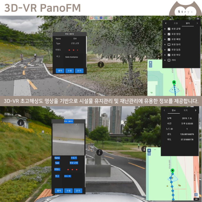
Our system is a web-based spatial information management system which gets 3D-VR UHD images of facilities such as roads and tunnels by using the MMS (Mobile Mapping System) equipment including LiDAR and, based on the images, provides information useful for monitoring facilities and managing facilities and disaster by integrating core technologies of the 4th industrial revolution including sensor fusion and AI. This system shows the location and status of facilities by presenting 360 degree panoramic images with 3D coordinates, detect damages of facilities from the images and store data related.
The system helps government ministries, public agencies, municipalities, facilities corporation and companies to collect, analyze and manage data necessary to improve business efficiency, make informed decisions and promptly take measures for facilities management/construction/repair and disaster management.
Product details
This product was developed as part of the collaboration matching platform established by the Ministry of the Interior and Safety(MOIS) and in collaboration with the Korea Infrastructure Safety Corporation(KISTEC).
1. Functions
Our system provides several essential functions, including:
1) Obtaining images of facilities and 3D spatial information
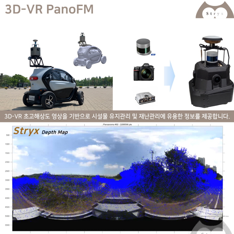
○ Getting UHD VR panoramic images (360°) of facilities including roads and tunnels by using the portable/vehicle-mounted MMS (Mobile Mapping System)* equipment, drones,
etc.
* MMS (Mobile Mapping System)*: It comprises LiDAR, GNSS/INS (Global Navigation Satellite System/Inertial Navigation System), camera, and so on. Among them, LiDAR obtains 3D spatial information about location and shape of facilities.
○ Converting data obtained by the MMS to map data and integrating the data with panoramic images
- Automatically identifying and classifying Points of Interest (POI) or specific objects in the images by using AI and assigning 3D coordinates
※ For privacy protection, images containing personal information such as faces and vehicle registration plates are blurred.
2) Constructing a facilities database
○ Building a web-based DB to store and manage spatial information
- Keeping and managing data about facilities including names, locations, authorities concerned, contacts, history of management (e.g. inspection and repair) and drawings
3) Analyzing damages of facilities
○ Identifying damaged facilities in the VR panoramic images by using AI
○ Representing locations of damaged facilities in GIS-based maps
○ Saving and managing data about damages including types, lengths, areas and risk revels
2. Uniqueness
This system uses our own solutions, i.e. the MMS equipment ('Argos-S') and technologies that we developed, from obtaining UHD VR images of facilities to integrating and managing data to provide the excellent 3D spatial information service which is highly realistic, accurate, precise and convenient as follows:
1) Obtaining accurate 3D spatial information by using high-performance LiDARs
2) Enabling localization even in the places where GNSS cannot work (e.g. tunnels) by using high-precision sensors
3) Showing 3D-VR panoramic images with a real omnidirectional field of view (360 degrees) which can be easily and quickly watched and used in digital maps
4) Providing realistic data of facilities based on 3D visualization of spatial information
5) Providing accurate spatial information quickly by applying the Depth Map* based on the sensor fusion technology we developed and AI
* Depth Map: This technology automatically detects, identifies and learns the status of and changes in objects and offers spatial information with high accuracy and precision
(absolute accuracy: within 1m, precision: 1cm or below).
Company Information
Address : 70 Donggyo-ro 25-gil, Mapo-gu, Seoul, 03991
Website : http://www.stryx.co.kr
We plan to expand our business to foreign markets through our global network based on MoU and co-marketing agreement with famous overseas companies such as Leica Geosystems (GIS(Geographic Information Systems) company, Switzerland) and Velodyne Lidar(LiDAR sensor company, United States).